Territory Information

The Territory Information service offered by the MRC de Vaudreuil-Soulanges is distinguished by its reliability, frequent updates, and exhaustive geographical information that is used to support managerial and professional decisions within the municipalities.
The Territory Information service also fulfills the needs of the MRC, especially regarding territory development, public and fire safety, property assessment, sustainable social development, built heritage, watercourses, and environmental concerns.
For more information, please contact the Territory Information service at info-territoire@mrcvs.ca.
Current Project
Appréciation des risques en zone inondable
Le projet, lancé par le ministère des Affaires municipales et de l’Habitation (MAMH) et le ministère de l’Environnement, de la Lutte contre les changements climatiques, de la Faune et des Parcs (MELCCFP), réunit les MRC de Vaudreuil-Soulanges, d’Argenteuil et de Deux-Montagnes.
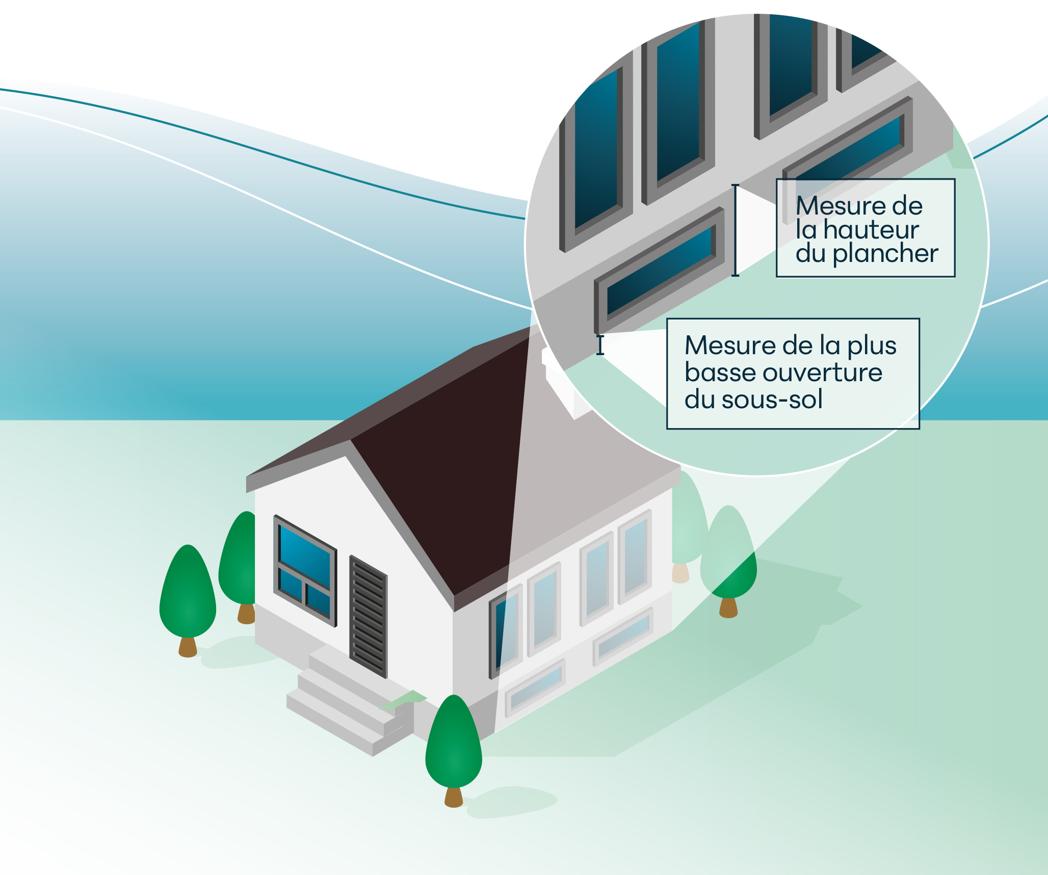
En partenariat avec les Ministères, la MRC de Vaudreuil-Soulanges participe à une étape importante de ce projet à l’avant-garde de ce qui se fait sur le territoire québécois. Les officiers municipaux de la MRC ont été désignés par le gouvernement du Québec pour prendre des mesures d’élévation autour des bâtiments résidentiels. Ces mesures permettront de déterminer les niveaux d’eau qui pourraient atteindre le bâtiment en période de crue. Le département de la géomatique est chargé de toutes les manipulations de données géospatiales ainsi que de la prise de données sur le terrain.
Plus spécifiquement, le levé topographique sera effectué près des bâtiments résidentiels de la plaine inondable afin de mesurer les élévations du 1er plancher (rez-de-chaussée) et de l’ouverture la plus basse (sous-sol). Ces données vont alimenter un calcul actuariel du risque pour faciliter la prise de décision afin de planifier l’instauration de mesures de mitigation et éviter des inondations.
Pour plus d’information, veuillez communiquer avec le service Info territoire au info-territoire@mrcvs.ca
Le ministère de l’Environnement, de la Lutte contre les changements climatiques, de la Faune et des Parcs travaille à l’élaboration d’un nouveau cadre normatif pour permettre une application plus uniforme et rigoureuse des normes visant les rives, le littoral, les zones inondables et les zones de mobilité. La mise en place d’un nouveau cadre réglementaire est l’une des mesures du Plan de protection du territoire face aux inondations.
Ce nouveau cadre sera instauré au fur et à mesure que les nouvelles cartes des zones inondables seront produites, et il viendra remplacer, graduellement, le régime transitoire. Ce chantier de cartographie sera réalisé notamment dans le cadre du projet INFO-Crue du MELCCFP.